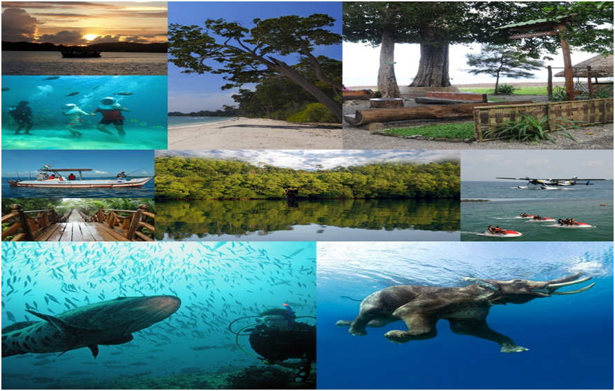
Andaman and Nicobar Islands is the largest archipelago system in the Bay of Bengal. This lies in a crescent that stretches from cape Negroid of Myanmar to Bandra Arc of Sumatra (Indonesia). The Andaman and Nicobar are separated by 10 Degree Channel. The Northernmost point is about 901 km away from the mouth of Hugly River and about 190 km from Myanmar. The Southernmost Island is Great Nicobar whose southernmost tip is only 150 km away from Sumartra, Indonesia. A&N Islands is latitudinally situated between 6 and 14 degrees, of the North Latitudes and between 92 and 94 degrees of East Longitude with 86.93 percent of land being recorded as tropical rain forest. Andaman and Nicobar Islands comprises 736 Islands, Islets and rocks. However, only 39 Islands are inhabited, 11 islands in South Andaman District, 14 in North & Middle Andaman District and 13 in Nicobars District. Total geographical area is 8249 sq. km. with a coastline of 1962 km. The Northern group of Islands, the Andaman group is 6408 sq.km. and the Nicobar group is 1841 sq.km. The Islands are exposed to marine influences and have a tropical climate, warm, moist and equable. The temperature ranges from 18ºC to 35º C. The proximity of the sea and the abundant rainfall prevents extremes of heat and these Islands experience both the Northeast and Southwest monsoons. The average annual rainfall ranges from 3000 to 3500 mm and humidity varies from 66% to 85%. In some years the Islands have experienced rains during all the months of the year, Cyclone occur during the monsoons, accompanied by very strong winds mainly during May and November and in some years during mid April. The normal rainfall of Port Blair town is 3180 mm. The rainfall data in the last 5 years is given in Statement 6.1.6.
The main part of Andaman group is composed of 204 islands and islets with three chief islands in the main group, North Andaman, South Andaman, Middle Andaman.
The dense forest which cover these islands and the innumerable exotic flowers and birds create a highly poetic and romantic atmosphere. Forests cover an area of 7171 Sq. Km. which is 86.93% of the total geographical area. Remaining land is revenue land and is used for human settlement, agriculture and developmental activities. Andaman and Nicobar Islands constituted nearly one fourth of India’s coast line. The Islands are located in a region identified under the seismic zone-V, corresponding to high incidence of seismic activity. The ecological sensitivity of ANIs is delicately poised and this circumscribes the capacity of these Islands to sustain human settlements. Andaman
The main part of Andaman group is composed of 204 Islands and Islets with here chief Islands in the main group, North Andaman, south Andaman, Middle Andaman, Baratang and Rutland islands, closely adjoining that they have been known as Great Andamans. To the south of Great Andaman is the Island of Little Andaman and these main Islands are surrounded by several hundred Islets, consists of mostly of mass of hills covered with dense tropical forests and separated by three straits and several creeks. The heavily forested mountains have the maximum elevation of about 700 metres and the indented coastline is marked by mangrove swamps.
The Nicobar Islands, beginning 120 km south of Little Andaman, comprise of 19 Islands with a total area of 945 sq.km. The chief Islands are Car Nicobar, Kamorta, Nancowrie and Great Nicobar. These Islands are partly hilly and partly flat.
The Islands are exposed to both monsoons with north easterly gale from November to January and south westerly gale from may to October. The average rainfall is 318 cm and the temperature varies between 23.9 degree to 30.2 degree centigrade throughout the year. The average rainfall is about 125binches spread over 7 months from May to November with high humidity. The climate is typically equatorial.
| Normal Rainfall at Port Blair | 3180 mm |
| Actual Rainfall at Port Blair | 3116.6 mm |
| Rainy days at Port Blair (No) | 159 |
| Mean Minimum Temperature at Port Blair | 24.6°C |
| Mean Maximum Temperature at Port Blair | 31.3°C |
| Mean Relative Humidity at Port Blair (0830hrs) | 80% |
| Mean Relative Humidity at Port Blair (1730hrs) | 83% |
| Mean Wind Speed at Port Blair (Km/Hr) | 6.7 |
There are around 516 villages (Both inhabited and uninhabited). The population as on 1st March, 2011, worked out to 3,79,944 as against 3,56,152 as on 1st March 2001. Total population of Andaman and Nicobar Islands accounts for 0.03 percent of the total population of India. In terms of the population this Union Territory comes 32nd among the States and UTs in India.