| Total Geographical Area | 123800 ha | |
| Total Forest Area | 104612 ha (84.50% of geographical area) | |
| Reserved Forest Area | 104612 ha | |
| Wildlife Sanctuary * | 7909 ha | |
| National Parks * | 3261 ha | |
| Mangrove Forest Area | 13162 ha | |
| * These areas have been notified with in Reserved Forest Area | ||
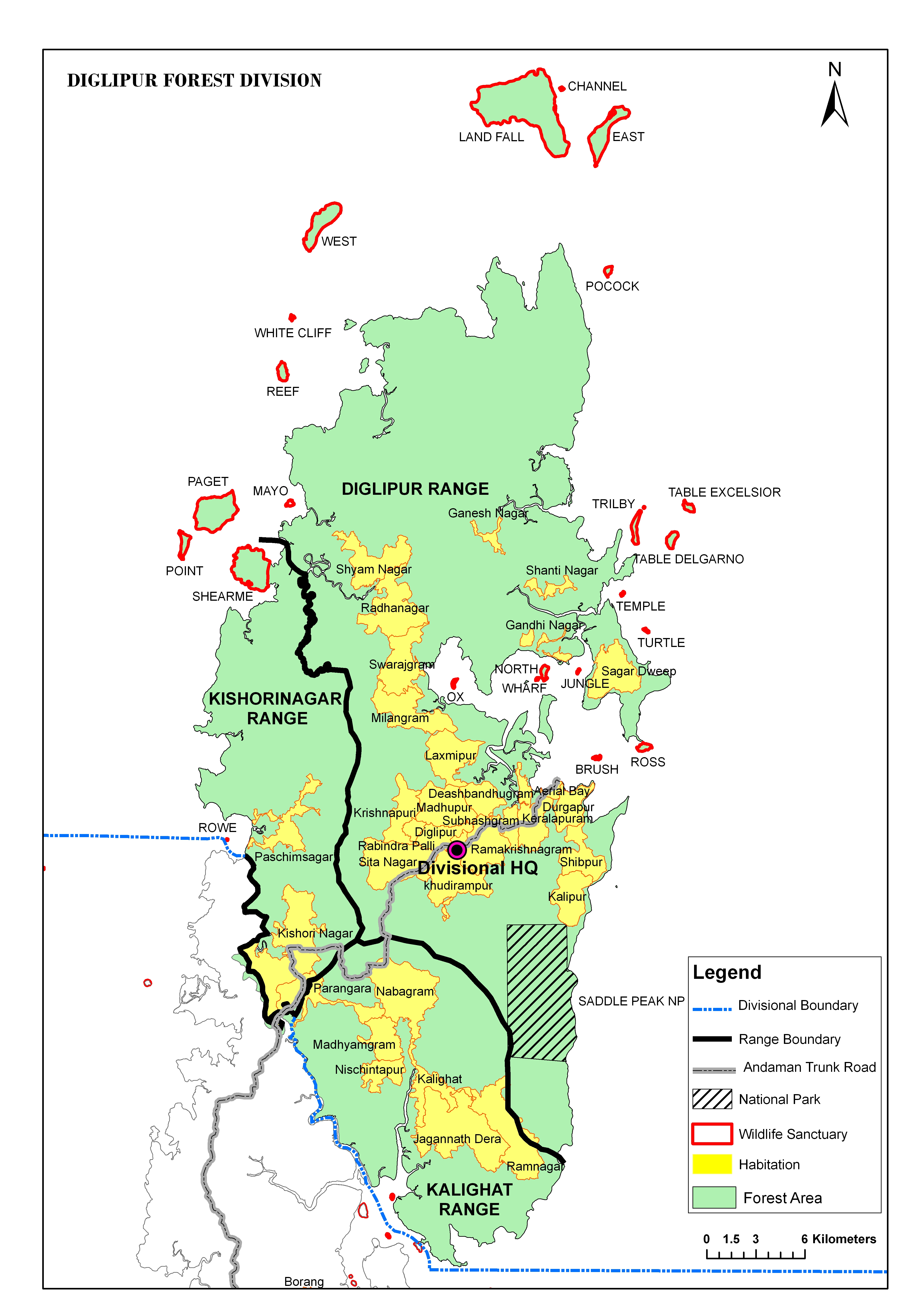
The Diglipur Forest Division is the northern most of the seven territorial Forest divisions, which comprise the main Andaman group of Islands, including Little Andaman Islands. The Diglipur Forest Division came into existence as a separate territorial division since May 1988.
This division comprises the forest area of the Northern portion of the main North Andaman Island along with its adjacent islands like Channel Island, Landfall Island, East Island, Peacock Island, Narcondam Island, Smith Island, Shearme Island, Paget Island, West Island and all other small Islands falling within the divisional boundary limits.
The Division has three territorial Ranges:-
| Sl. No. | Name of Range | Area (Sq Km) | No. of Beats |
|---|---|---|---|
| 1 | Diglipur Range | 663.86 | 22 |
| 2 | Kalighat Range | 190.95 | 7 |
| 3 | Kishorinagar Range | 165.23 | 4 |
| Total Geographical Area | 99000 ha | |
| Total Forest Area | 92898 ha (79.28% of geographical area) | |
| Reserved Forest Area | 92898 ha | |
| Wildlife Sanctuary * | 17228 ha | |
| Mangrove Forest Area | 12726 ha | |
| * These areas have been notified with in Reserved Forest Area | ||
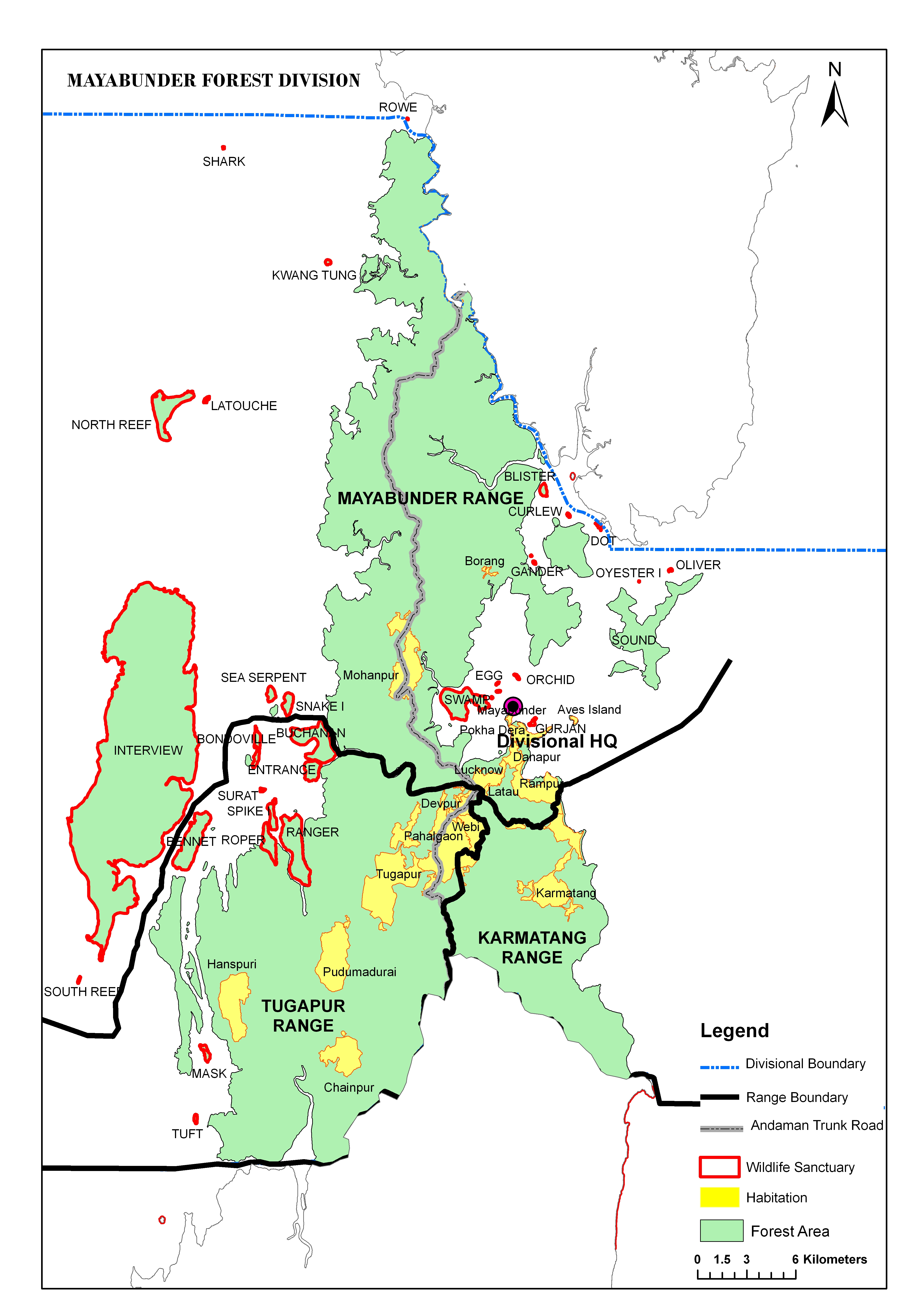
The Mayabunder Forest Division is one of the six territorial forest divisions, which cover the Andaman group of island. This Division came into existence as a separate territorial division since May 1988.
The division comprises the forest area of northern 1/3rd of Middle Andaman Main Island, southern 1/3rd of North Andaman Main Island and the entire areas of Sound Island, Interview Island, Buchanan, Ranger, Anderson, Stewart Island and all other small Islands falling within the divisional boundary limits.
The Division has three territorial Ranges:-
| Sl. No. | Name of Range | Area (Sq Km) | No. of Beats |
|---|---|---|---|
| 1 | Mayabunder Range | 445.42 | 14 |
| 2 | Tugapur Range | 309.96 | 8 |
| 3 | Karmatang Range | 102.71 | 6 |
| Total Geographical Area | 96500 ha | |
| Total Forest Area | 85712 ha (79.28% of geographical area) | |
| Reserved Forest Area | 52428.5 ha | |
| Wildlife Sanctuary * | 1466 ha | |
| National Parks * | 91 ha | |
| Mangrove Forest Area | 13533 ha | |
| * These areas have been notified with in Reserved Forest Area | ||
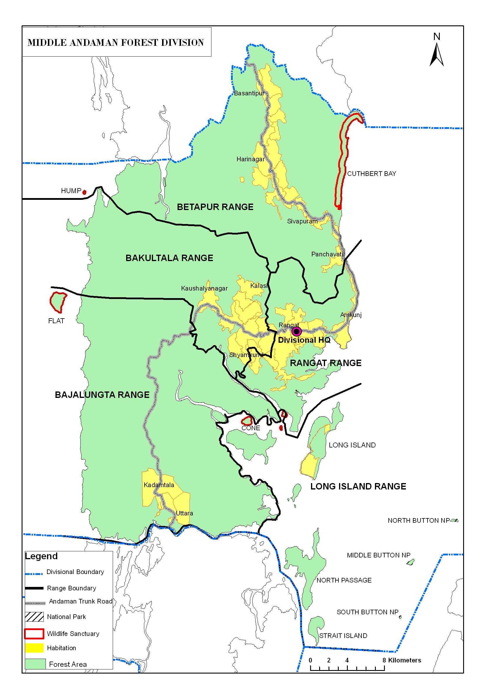
Middle Andaman Forest Division is one of the largest territorial Forest Divisions of the Department of Environment & Forests, Andaman & Nicobar Islands. The area comprising this division are the forest area of southern 2/3rd of Middle Andaman Island and the entire area of Long Island, Flat Island, Guitar Island, Porlob Island, North Passage Island, Strait Island, Middle, North & South Buttons Islands, Parkinson, Oyster Island, Cone Island, Barren Island, Round Island and few unnamed islets
The Division has five territorial Ranges:-
| Sl. No. | Name of Range | Area (Sq Km) | No. of Beats |
|---|---|---|---|
| 1 | Betapur Range | 288.009 | 11 |
| 2 | Rangat Range | 112.502 | 5 |
| 3 | Bakultala Range | 107.15 | 5 |
| 4 | Bajalungta Range | 251.934 | 5 |
| 5 | Long Island Range | 63.77 | 3 |
| Total Geographical Area | 166500 ha | |
| Total Forest Area | 131994 ha (79.28% of geographical area) | |
| Reserved Forest Area | 130375 ha | |
| Wildlife Sanctuary * | 2811 ha | |
| National Parks * | 10803 ha | |
| Mangrove Forest Area | 11782 ha | |
| * These areas have been notified with in Reserved Forest Area | ||
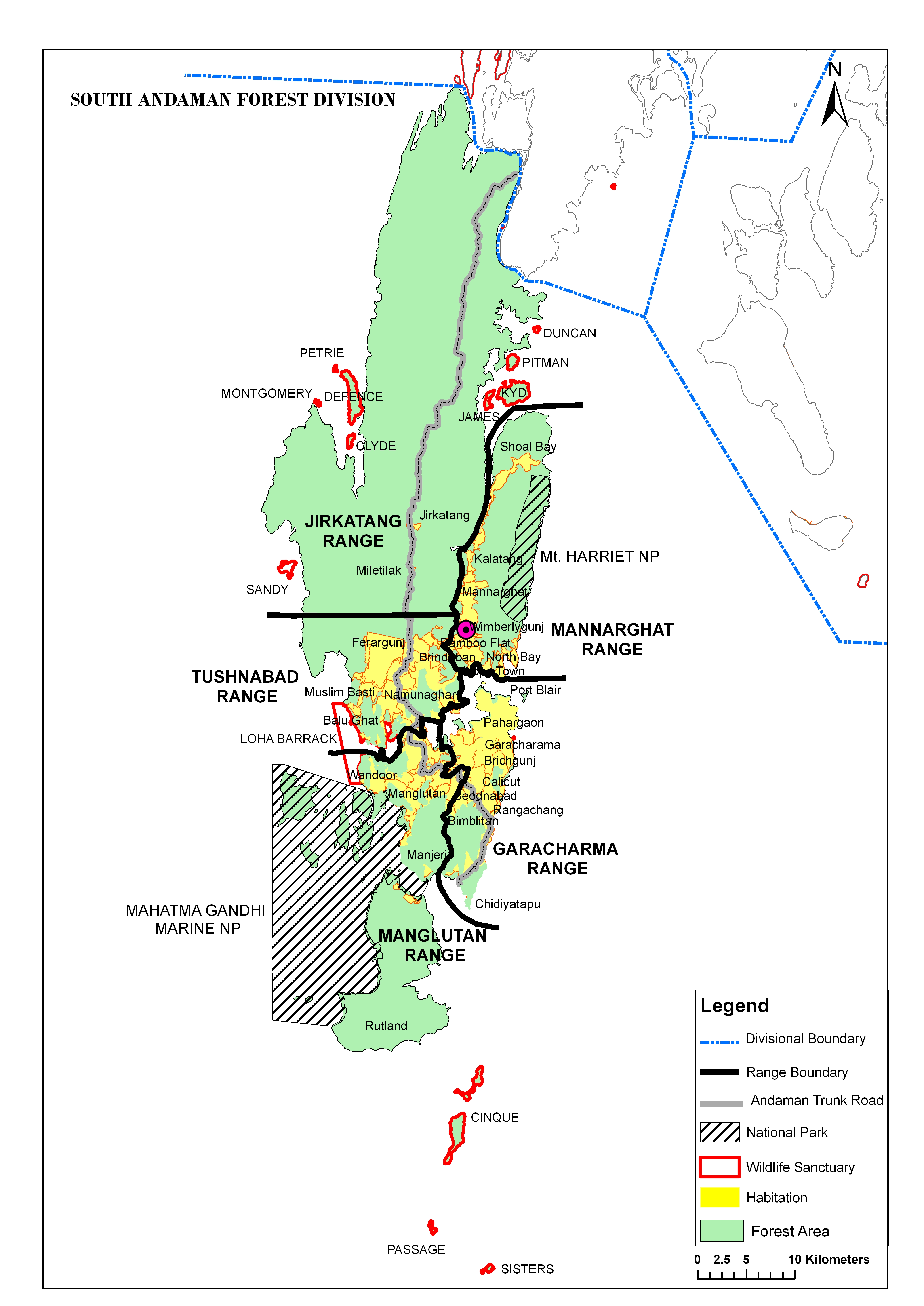
South Andaman Forest Division is one of the six Territorial Divisions of the Department of Environment and Forests, Andaman & Nicobar Islands.
There are about 40 Islands comprising this Division of which South Andaman and Rutland Islands are main Islands. The narrow channels most of which are navigable separate all the Islands from one another. Port Blair town, the capital of the Union Territory, is situated in South Andaman Island. However, the Administrative Headquarters of the Forest Division is located at Wimberlygunj.
The Division has five territorial Ranges:-
| Sl. No. | Name of Range | Area (Sq Km) | No. of Beats |
|---|---|---|---|
| 1 | Garacharma Range | 8 | |
| 2 | Manglutan Range | 8 | |
| 3 | Mannarghat Range | 9 | |
| 4 | Tushnabad Range | 7 | |
| 5 | Jirkatang Range | 2 |
| Total Geographical Area | 37771 ha | |
| Total Forest Area | 36331 ha (91.50% of geographical area) | |
| Reserved Forest Area | 36331 ha | |
| Wildlife Sanctuary * | 1842 ha | |
| * These areas have been notified with in Reserved Forest Area | ||
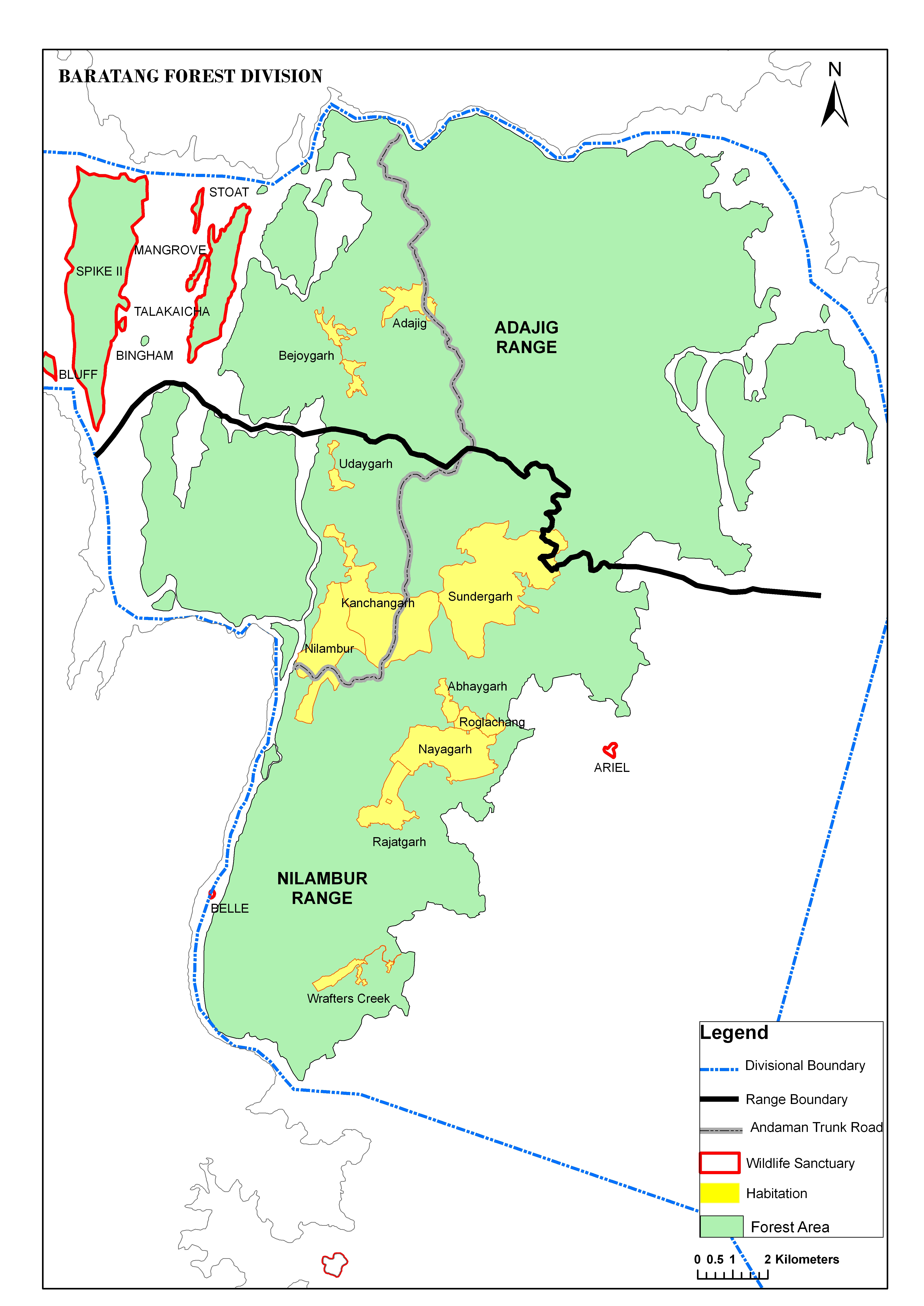
The Baratang Forest Division is one of the seven territorial divisions functioning under the Department of Environment & Forests. It was created during November 1979 for the intensive management of forests.
It covers mainly the Baratang Island, Ritchie's Archipelago and all adjoining islands falling within the boundary limits of the Division. The distance between the Northern most point of the Division and Southern most point of the Division is about 61 kms and the width varies from less than a km to 18 kms. There are two distinct groups of islands comprising this Division. One group consists of Baratang and adjoining islands and the other consists of the Ritchie's Archipelago. The nearest distance between these two groups of Islands is about 13kms from shore to shore.
The principal islands comprising the Division are Baratang, Evergreen Colebrooke, Spike, Talakaicha, Havelock, Peel, Wilson, John Lawrence, Henry Lawrence, Outram, Neil and Sir Hugh Ross. Narrow channels separate all the above islands from each other, most of which are navigable and sheltered. A channel namely Deligent Strait separates the Baratang group of islands and Ritchie's Archipelago, is quite navigable.
The Division has two territorial Ranges:-
| Sl. No. | Name of Range | Area (Sq Km) | No. of Beats |
|---|---|---|---|
| 1 | Nilambur Range | 5 | |
| 2 | Adajig Range | 217.77 | 6 |
| Total Geographical Area | 73799 ha | |
| Total Forest Area | 70365 ha (95% of geographical area) | |
| Reserved Forest Area | 70365 ha | |
| Wildlife Sanctuary * | 199 ha | |
| * These areas have been notified with in Reserved Forest Area | ||
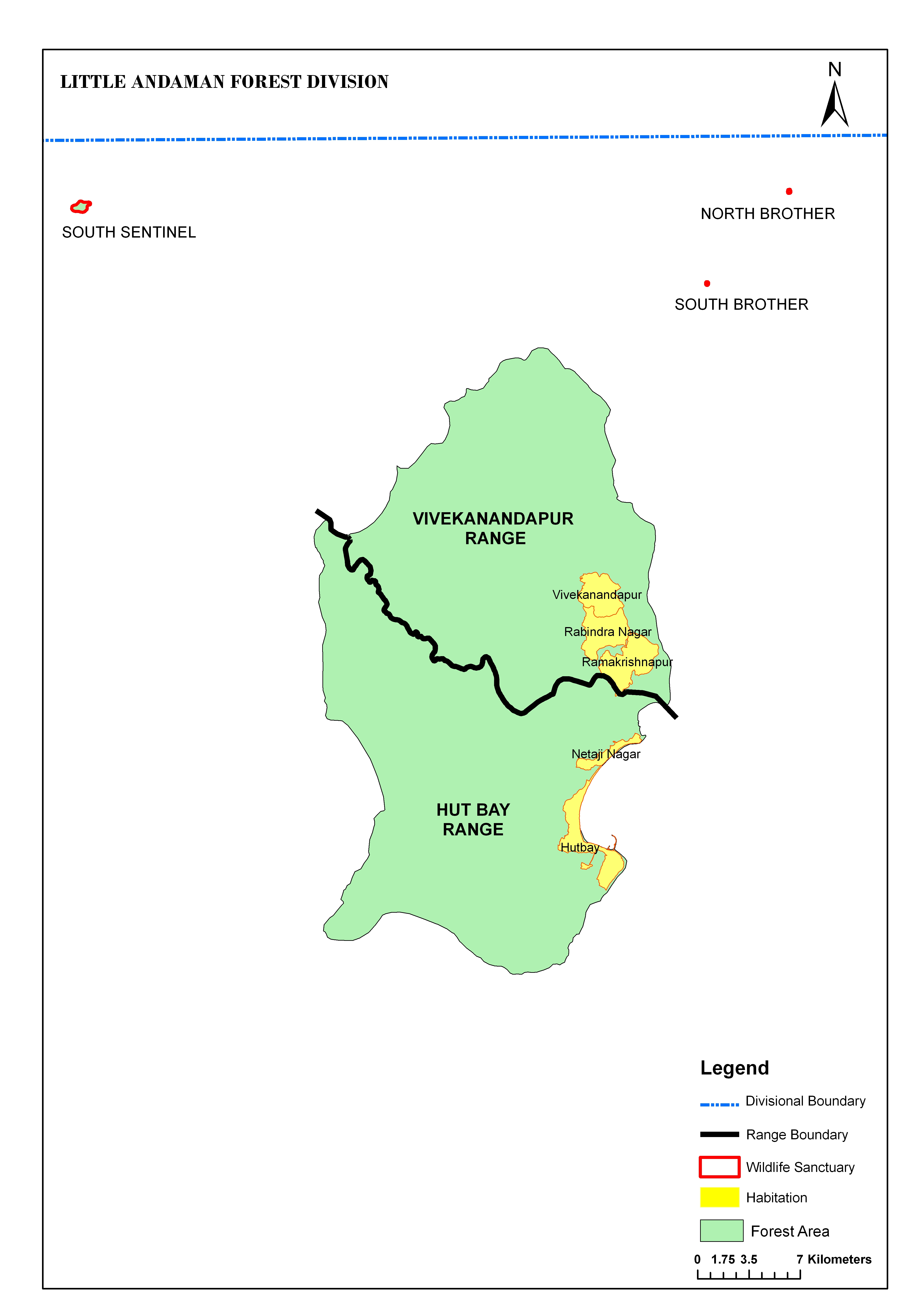
The Little Andaman Forest Division is one of the seven territorial divisions functioning under the Department of Environment & Forests. It was created during 1975 for the intensive management of forests.
On establishment of Andaman & Nicobar Islands Forests & Plantation Development Corporation Ltd. for the development of logging, marketing and raising of plantations in the year 1977, the harvestable forests were leased out to this corporation. The divisional headquarters were shifted to Campbell Bay under Nicobar Forest Division subsequently. Again in 2002 a new Forest Division named "Little Andaman Forest Division" was created with headquarters at Hut Bay.
Little Andaman Island is the Southernmost Island of the Andaman Group of Islands situated about 120 Kms from the southern tip of South Andaman Island. Hut Bay is the administrative centre of this Island which is about 140 Kms from Port Blair, the capital town of the Union Territory and 150 Kms from Car Nicobar, the district Headquarters of Nicobar district. The Island is bound by "Ten degree Channel" in the South, South Brother Island in the north and Bay of Bengal Sea in the east and west. Api Island is the nearest island in the west coast of Little Andaman. Other off-lies are South Sentinel & Brother Islands in the northwest & northeast respectively. The Island has an elongated shape and spreads in north - south direction. Maximum length of the Island is about 40 Kms and the maximum width is 25 Km.
The Division has two territorial Ranges:-
| Sl. No. | Name of Range | Area (Sq Km) | No. of Beats |
|---|---|---|---|
| 1 | Hut Bay Range | ||
| 2 | Vivekanandapur Range |
| Total Geographical Area | 184100 ha |
| Total Forest Area | 154200 ha (84.00% of geographical area) |
| Reserved Forest Area | NIL |
| Protected Forest Area | 154200 ha (84.00% of geographical area) |
| Tribal Reserve Area | 175500 ha (95.00% of geographical area) |
| Wildlife Protected Area | 55530 ha (30.00% of geographical area) |
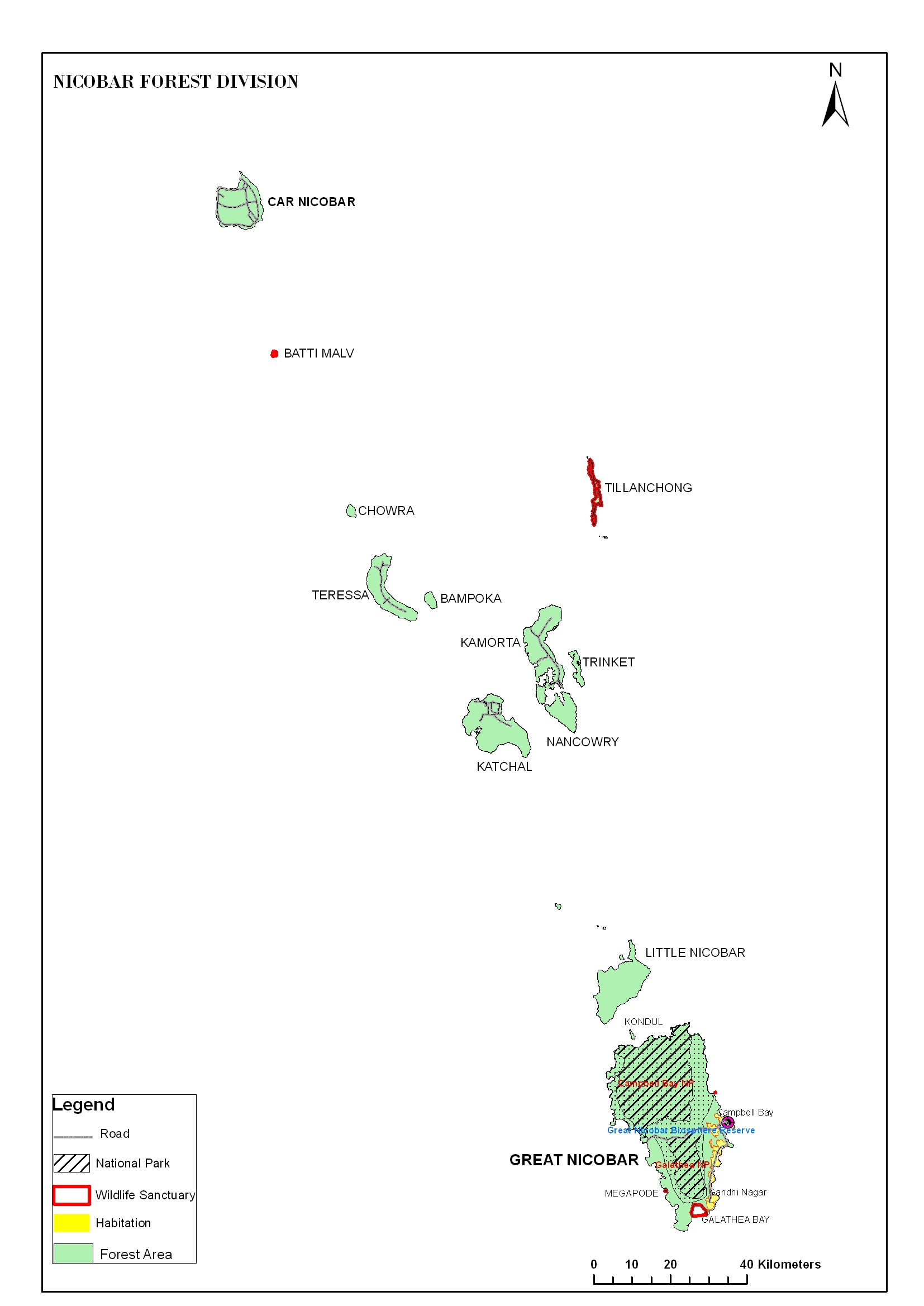
The Nicobar Forest Division is the southern most of the seven territorial Forest divisions, which comprise the main Nicobar group of Islands. This division comprises the forest area of the Southern most part of the Nicobar group of Islands which includes Great Nicobar, Little Nicobar and Car Nicobar and other small group of Islands.
The Division has four wildlife Ranges:-
| Sl. No. | Name of Range | No. of Beats |
|---|---|---|
| 1 | Campbell Bay (HQ) Range | 05 |
| 2 | Campbell Bay (wildlife) Range | - |
| 3 | Katchal Range | 02 |
| 4 | Kamorta Range | 04 |
| 5 | Car Nicobar Range |
The major activities of the Division includes plantation work, protection and maintenance of PA and community participation. The Division is well equipped with staff and other infrastructure. There are two National Parks, four Wildlife Sanctuaries and one Biosphere Reserve. The Great Nicobar Biosphere Reserve encompasses a large part of the Island of Great Nicobar which is the largest of the Nicobar Islands. The reserve was declared in January 1989 and it incorporates two National Parks i.e Campbel bay National Park on the Northern part of Island and Galathea National Park in the Southern interior. In year 2013 it was included in the list of Man and Biosphere program of UNESCO to promote sustainable development. The four wildlife Sanctuaries are:-
| Total Geographical Area | 31278 ha |
| Total Forest Area | 28229 ha (90.25% of geographical area) |
| Reserved Forest Area | 28229 ha 90.25% of geographical area) |
| Protected Forest Area | NIL |
| National Park | 106 ha |
| Wildlife Sanctuary | 13115 ha (41.93% of geographical area) |
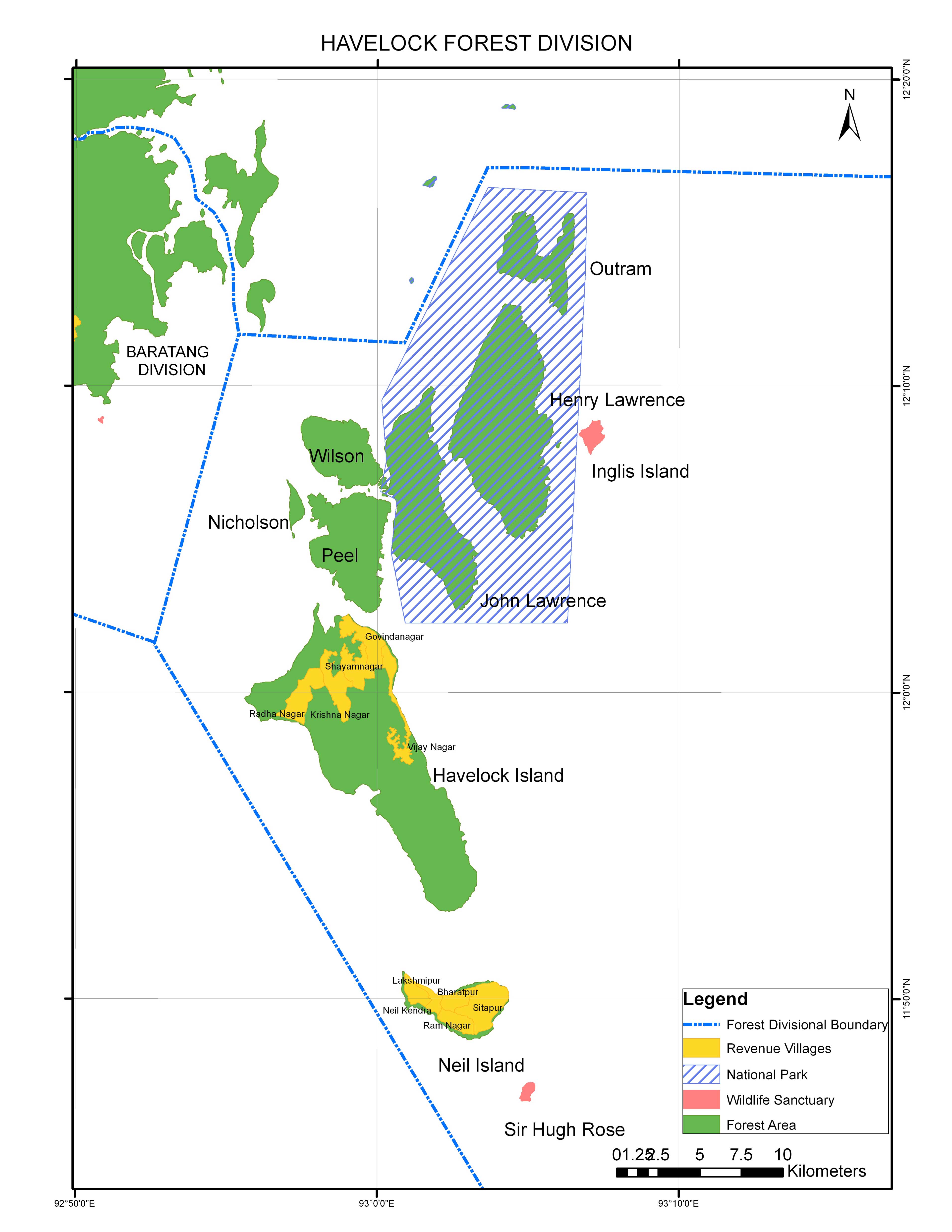
This Division was created on 01/04/2008 vide A & N Administration Gazette Notification No. 174 dated 23/07/2007. The main activities of the Division includes protection, raising of plantaions, construction works etc. The Administrative jurisdiction of Havelock Forest Division extents on the following Islands:-
| Sl. No. | Name of the Island | Geographical Area (Sq Km) | Legal Status | Non-Forest Revenue Area (Sq Km) | Forest Area (Sq Km) |
|---|---|---|---|---|---|
| 1 | Havelock | 113.93 | Partly Revenue & Reserved Forests | 18.33 | 95.6 |
| 2 | Neil | 18.9 | Partly Revenue & Reserved Forests | 12.16 | 6.77 |
| 3 | John Lawrence | 41.8 | Part of R.TM National Park | - | 41.8 |
| 4 | Henry Lawrence | 65.63 | Part of R.TM National Park | - | 65.63 |
| 5 | Outram | 19.99 | Part of R.TM National Park | - | 19.99 |
| 6 | South Button | 0.03 | Part of R.TM National Park | - | 0.03 |
| 7 | Middle Button | 0.44 | Part of R.TM National Park | - | 0.44 |
| 8 | North Button | 0.44 | Part of R.TM National Park | - | 0.44 |
| 9 | Inglis | 3.58 | Part of R.TM National Park | - | 3.58 |
| 10 | Nicholson | 2.54 | Reserved Forests | - | 2.54 |
| 11 | Peel | 27.84 | Reserved Forests | - | 27.84 |
| 12 | Sir Hugh Ross | 1.06 | Wildlife Sanctuary | - | 1.06 |
| 13 | Wilson | 16.71 | Reserved Forests | - | 16.71 |
| 14 | One islet between Nicholson & Peel | 0.65 | Reserved Forests | - | 0.65 |
| Total | 30.49 | 283.08 | |||
The Divisional Headquarters is located in Havelock.The Division comprises of two territorial Ranges namely Havelock Range & John Lawrence Range.
The Rani Jhansi Marine National Park notified in 1996 covers an area of 319.53 Sq.km(132.06Sq.km of Terrestrial area + 187.47 Sq.km of Marine area) is present under this Division.
Forest Types :The Forest types of the Division are
The Division is well equipped with staff and other infrastructures. There are various eco- friendly sites at both Havelock and Neil Island.
Havelock:-
Neil:-